Windows software for hydrographic surveying and processing
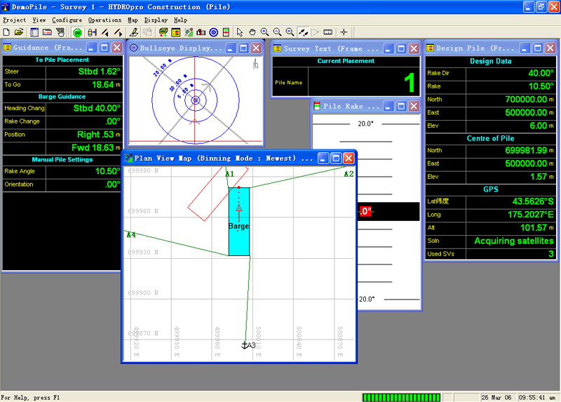
Trimble's HYDROpro? Navigation software is an easy to use software solution for today's hydrographic surveyor. Designed with superior performance and efficiency in mind, it allows for significant improvements in productivity on even the most complex marine survey application.
The HYDROpro Navigation software operates on Windows operating systems, and includes a flexible data acquisition and storage system that is compatible with Microsoft Access.
The software's flexible operation provides multiple ?steerby' capability, allowing guidance of multiple vessels and offsets to multiple guidance objects such as targets, lines, or routes. Guidance between mobile vessels is available. Any number of vessels can be monitored from a single location or across a network. Background files can be displayed graphically to show position in relation to guidance objects, coastal features, and so on.
The HYDROpro NavEdit software option integrates seamlessly with the HYDROpro Navigation software. With it, you can graphically filter and edit depth and tide data. Then export the data to either our optional Terramodel? or your preferred processing software. The Terramodel? Windows processing software handles large data sets quickly for volumes and 3D visualizations.
-
interfaces to echosounders, heading sensors, environmental sensors, acoustic, GPS and Total Station positioning
-
all data stored in Microsoft Access database
-
graphical data cleaning